


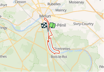
Du Pont de Melun au Pont de Bois-le-Roi et Chartrette

mathis01
User

Length
17.4 km

Max alt
98 m

Uphill gradient
172 m
Km-Effort
19.7 km

Min alt
35 m

Downhill gradient
171 m
Boucle
Yes
Creation date :
2021-07-24 10:04:50.265
Updated on :
2021-07-24 10:21:27.491
1h30
Difficulty : Medium
--
Difficulty : Very easy
--
Difficulty : Very easy

FREE GPS app for hiking
 SityTrail
IGN / Geographical institutes
SityTrail Plus
The world is yours!
About
Trail Walking of 17.4 km to be discovered at Ile-de-France, Seine-et-Marne, La Rochette. This trail is proposed by mathis01.
Positioning
Country:
France
Region :
Ile-de-France
Department/Province :
Seine-et-Marne
Municipality :
La Rochette
Location:
Unknown
Start:(Dec)
Start:(UTM)
475558 ; 5373578 (31U) N.
Comments